
Affordable Processing
LiDAR & Photogrammetry data processing. Deliverables with only one click. Results quality checked by experts.
Pay-per-area scalable business model.
.png)
Quick Turnaround
Get results in as little as 1 hour.
Contours & Surfaces in as little as 1 day. Planimetrics (Linework) in 3–4 days.
The highest quality results every time.
.png)
Hardware Compatibility
Upload data from any LiDAR system.
ROCK Cloud produces deliverables from any LiDAR file, including orthomosaics & images.
Increases the accuracy of DJI L1 data.
Enterprise Data Processing Platform
ROCK Cloud is affordable, fast & easy to use
Packed with all of features you need
Learn more in-depth about the features here ←

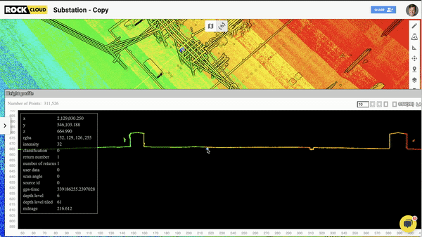
View & Modify Data
Easily view and modify 3D Topographic Surfaces directly in the ROCK Cloud

Manage Projections
Use any standard projection or designate a custom coordinate system with a combined scale factor.

Compare, Align & Merge
Make real-time adjustments to your project data to help achieve the best results.
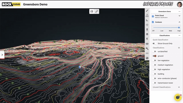
Topographic Surfaces
Processing that data with the ROCK Surveyor provides the topographic deliverables for everything in-between the boundaries.

Data Storage
Never worry about failing hard drives ever again. All of your data is securely stored on the ROCK Cloud.

Data Sharing
Share projects with your clients from email or share to a wider audience with share links. No additional licenses necessary!

Custom Branding
Include your company profile and logos in order to brand the datasets you're sharing.
L1 Strip Alignment
Improve your DJI Zenmuse L1 accuracy with surface matching and ROCK Cloud Strip Alighment.

Calculate Stockpile Volumetrics
Use the Stockpile Tool to click and draw a polygon around any object in your point cloud and calculate the volume and cut/fill.

Establish GCPS
& Accuracy Reports
Effortlessly upload a CSV of ground control points to your project or add them in. Use the Quick Alignment Tool to align your dataset.
- Additional Features -
• Auto GCP Align
• Measure, label and coordinate project sites
• Re-classify and edit LiDAR points
• View enormous datasets on any device around the world
• Generate Linework and Planimetrics
• Orthomosaic Support
• Import 2d and 3d measurements on your project
• Export 2d and 3d measurements created on your project
• Live Chat and Email Support available for Business & Enterprise subscription tiers*


Streamlined Workflow
Developed to make your job way easier
Simply upload and process your data fast with just one click.
All of your data lives securely on the ROCK Cloud — no need for expensive data storage.
Easily share your final deliverables with your client in the file formats you need.
Quality Assurance & Quality Controlled by real humans.

Survey-Grade Accuracy
Take your 3D LiDAR data to the next level
Supports the use of Ground Control Points, Checkpoints, and KML / Shapefiles for maximum integration of your existing files.
Generate Accuracy Reports compliant with professional survey standards.
Get your deliverables in the Coordinate Systems you need. All standard systems included, from state plane to custom coordinate systems!

Enterprise Business Solutions
ROCK Cloud works for your whole organization
Receive 1-on-1 ROCK Solid Support for all of your questions and troubleshooting needs via phone, live chat and email.

Professional Deliverables
Survey-grade deliverables, fast & easy
ROCK Planimetrics - Generate accurate linework and CAD drawings from your data.
ROCK Surveyor - Produce a Digital Elevation Model and Contours for accurate insight into the ground topography.
ROCK Vegetation - See through dense vegetation and deliver safe and uninterrupted electricity for power-line corridor management.
ROCK SLAM - Get an accurate point cloud from scanning 3D data in GPS denied environments.
.png)
"ROCK Cloud has been such a breeze to use as far as simplicity and straightforwardness goes. Using it to process my data has been great!"

Topographic Surveys
Generate topographic surveys from raw uploaded data using ROCK Surveyor. Get Bare Earth Classified LAS, Contours, Digital Elevation Model (DEM) Surface and Ground Control Accuracy Report in hours instead of days. Enhance ROCK Surveyor with Breaklines and add in shots captured by RTK or total stations to augment the LiDAR data with enhanced accuracy.
See the data for yourself.
View the R360 datasets & recognize the power.


"Using the ROCK Cloud was an easy experience. Turnaround met the suggested timeline. The results they said they would deliver; were delivered. Not to mention, their team reached out quickly to answer all of our questions."

ROCK Solid Support
Customer Support is paramount at ROCK Robotic. Our onboarding, training, technical support and online resources will give you the confidence and ability to succeed with your L1 data.

ROCK Strip Alignment
Easily improve the accuracy of your L1 data. ROCK Strip Alignment takes your uploaded LAS, along with the trajectory and analyzes the point cloud to produce a new optimized point cloud.

Compatible with DJI Zenmuse L1
Use the full power of ROCK Cloud to make your data better


Software that scales with you
Pay-as-you-grow, modeled for your success
Resources to help you succeed
Rest-assured knowing we have it all figured out


